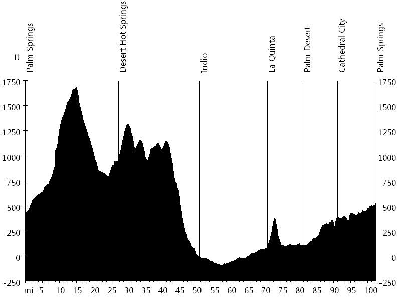
tourofcalifornia.org

Bike Ride: Tour de Palm Springs

Find a Tour de Palm Springs interactive course map, route profile, and ride description, as well as pictures, personal notes, and more about the Tour de Palm Springs bike ride.

104 miles with 3,100 feet of elevation gain*

Locate ride on interactive map.

[Interactive Course | enlarge]

Tour de Palm Springs - Route Profile
[Route Profile]

Tour de Palm Springs - Counties Visited:

Riverside County

Tour de Palm Springs - Cities/Towns Visited:

Palm Springs, Desert Hot Spings, Indio, La Quinta, Indian Wells, Palm Desert, and Cathedral City

Tour de Palm Springs - Climbs:

Mile 71 (cat. 4)

Tour de Palm Springs - Stops:

Mile 15 (Worsley), 27 (Dillon), 51 (Travel Centers), 71 (Fritz Burns Park), and 91 (Lowe's)

Tour de Palm Springs - Description:

The Tour de Palm Springs is a big cycling event with multiple distances, ideal for beginners. The course is mainly flat with some rolling hills and minor climbs.

It starts in downtown Palm Springs and initially heads north towards Twentynine Palms, slightly climbing. Then it leads south-east towards Desert Hot Springs and follows Dillon Road all the way to Indio.

The second half of the ride, which is more urban than the first half, leads north-west and visits several desert towns on the way back to Palm Springs.

Tour de Palm Springs - Pictures:

Tour de Palm Springs - Wind Farm
[Wind Farm]

Tour de Palm Springs - Happy Birthday, Bob!
[Happy Birthday, Bob!]

Tour de Palm Springs - Personal Notes:

A few of the Renegades went to ride the century: old man Bob McI., who turned 73, Bart B., Tom R., and myself. Initially we stayed together, but soon we started riding faster and Bob fell back.

We all took turns pulling, but Bart did the most work. Only a few other riders were able to help in the rotation because of the fast pace. At some point Bart missed a turn though, and we did not see him again until the finish line.

Tour de Palm Springs - Current Weather:

Weather Forecast
TourOfCalifornia.org