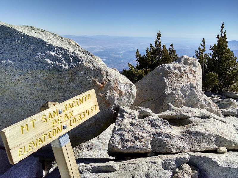
Summit elevation: 10,834 feet
San Jacinto Peak Trail: 11 miles with 2,500 feet of climbing
Marion Mountain Trail: 12 miles with 4,700 feet of climbing
Seven Pines Trail: 15 miles with 5,200 feet of climbing
Fuller Ridge Trail: 16 miles with 4,800 feet of climbing
Deer Springs Trail: 19 miles with 5,400 feet of climbing
Devil's Slide Trail: 20 miles with 6,100 feet of climbing
Mount San Jacinto is the most prominent peak in Southern California (third in California behind Mount Whitney and Mount Shasta). It is one of three peaks with an altitude higher than 10,000 feet and with at least 500 meters prominence (the other two are Mount San Gorgonio and Mount Baldy).
The peak offers spectacular 360-degree views of the San Jacinto Mountains, San Bernardino Mountains, San Gabriel Mountains, Santa Ana Mountains, and Mojave Desert.
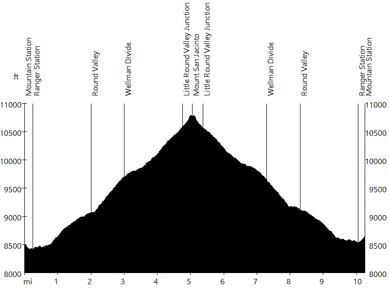
Route Profile • San Jacinto Peak Trail
San Jacinto Peak Trail starts at the mountain station of Palm Springs Aerial Tramway. After a paved descent to Long Valley, it passes the ranger station and leads west to Round Valley (camp at 9,100 feet) and Wellman Divide. Then the trail leads north, switches back, and merges with the one coming up from Idyllwild. After passing the summit hut, the trail leads over some boulders up to the summit.

Route Profile • Marion Mountain Trail
Marion Mountain Trail starts at Marion Mountain Campground, about 7 miles north of Idyllwild off Highway 243. After 2.8 miles, it reaches Deer Springs / Seven Pines Junction and enters the Pacific Crest Trail (PCT). After 0.5 miles (3.3 total), the trail reaches Fuller Ridge Junction and leaves the PCT. After 1 mile (4.3 total), it reaches Little Round Valley (camp at 9,800 feet). After 1.6 miles (5.9 total), the trail reaches Wellman Divide Junction. After 0.3 more miles (6.2 total), it reaches San Jacinto Peak.
Route Profile • Seven Pines Trail
Seven Pines Trail starts 1.6 miles after Dark Canyon Campground (dirt road), about 7 miles north of Idyllwild off Highway 243. After 3.5 miles, it reaches Deer Springs / Marion Mountain Junction and enters the Pacific Crest Trail (PCT). After 0.5 miles (4 total), the trail reaches Fuller Ridge Junction and leaves the PCT. After 1 mile (5 total), it reaches Little Round Valley (camp at 9,800 feet). After 1.6 miles (6.6 total), the trail reaches Wellman Divide Junction. After 0.3 more miles (6.9 total), it reaches San Jacinto Peak.

Route Profile • Fuller Ridge Trail
Fuller Ridge Trail starts at Fuller Ridge Camp, about 10 miles north of Idyllwild off Highway 243 (8 on dirt road 4S01). It is a section of the Pacific Crest Trail (PCT). After 2 miles, the trail offers a great view of Mount San Jacinto. After 3 miles (5 total), it reaches Fuller Ridge Junction and leaves the PCT. After 1 mile (6 total), the trail reaches Little Round Valley (camp at 9,800 feet). After 1.6 miles (7.6 total), it reaches Wellman Divide Junction. After 0.3 more miles (7.9 total), the trail reaches San Jacinto Peak.

Route Profile • Deer Springs Trail
Deer Springs Trail starts about half a mile north of Idyllwild off Highway 243. After 2.3 miles, it reaches Suicide Rock Junction. After 1.8 miles (4.1 total), the trail reaches Strawberry Juntion (camp at 8,000 feet) and enters the Pacific Crest Trail (PCT). After 2.3 miles (6.4 total), it reaches Marion Mountain / Seven Pines Junction. After 0.5 miles (6.9 total), the trail reaches Fuller Ridge Junction and leaves the PCT. After 1 mile (7.9 total), it reaches Little Round Valley (camp at 9,800 feet). After 1.6 miles (9.5 total), the trail reaches Wellman Divide Junction. After 0.3 more miles (9.8 total), it reaches San Jacinto Peak.

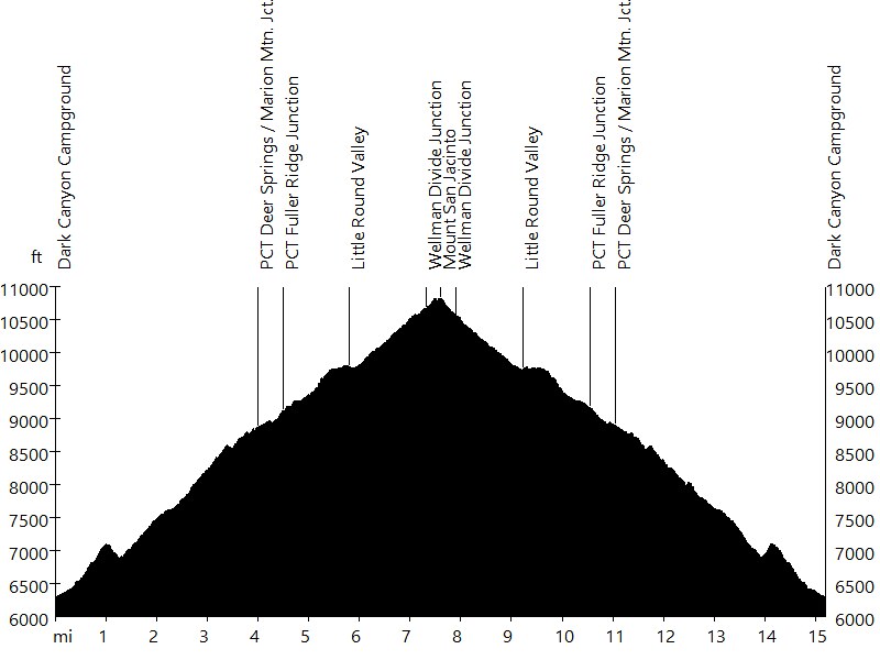
Route Profile • Devil's Slide Trail
Devil's Slide Trail starts at Humber Park in Idyllwild, near Tahquitz and Suicide Rock. After 2.5 miles, it reaches Saddle Junction and enters the Pacific Crest Trail (PCT). After 1.9 miles (4.4 total), the trail reaches Wellman Divide Junction and leaves the PCT. After 1 mile (5.4 total), it reaches Wellman Divide. After 2.4 miles (7.8 total), the trail reaches Little Round Valley Junction. After 0.3 more miles (8.1 total), it reaches San Jacinto Peak. From here on options include returning or continuing in a loop.
In case of a loop, the trail returns to Little Round Valley Junction, and after 1.6 miles (10 total), reaches Little Round Valley (camp at 9,800 feet). After 1 mile (11 total), the trail reaches Fuller Ridge Junction and re-enters the PCT. After 0.5 miles (11.5 total), it reaches Marion Mountain / Seven Pines Junction. After 2.3 miles (13.8 total), the trail reaches Strawberry Junction (camp at 8,000 feet). After 2.3 miles uphill (16.1 total), it reaches Wellman Divide Junction, from where it continues down to Saddle Junction and back to Humber Park.
Other trails include Cactus to Clouds Trail.
Mount San Jacinto • Interactive Map
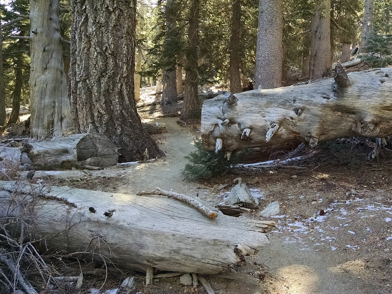
Mount San Jacinto • Pictures
San Jacinto Peak Trail

View from Wellman Divide

San Jacinto Peak Trail

Summit Hut

Summit Boulders
Mount San Jacinto
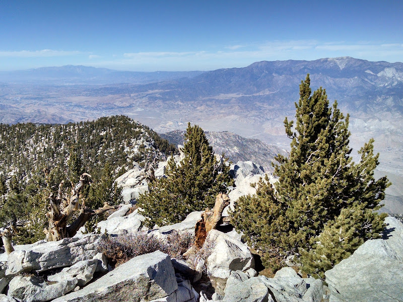
View from Mount San Jacinto

View from Mount San Jacinto

View from Mount San Jacinto

View from Mount San Jacinto

View from Mount San Jacinto

Mount San Jacinto in Winter

Mount San Jacinto

Mount San Jacinto
By: Bernd Straehle
See Also: Hiking & Backpacking