Mountain bike rides by distance and elevation gain
Sierra Peak via Black Star Canyon: 25 miles with 3,600 feet of climbing
Ortega Highway - Santiago Peak - Ortega Highway: 25 miles with 6,200 feet of climbing
Harding Truck Trail and Silverado Canyon: 27 miles with 3,600 feet of climbing
Santiago Peak and Modjeska Peak via Silverado Canyon: 27 miles with 4,700 feet of climbing
Santiago Peak via Harding Truck Trail: 28 miles with 5,100 feet of climbing
Black Star Canyon and Skyline Drive: 29 miles with 4,500 feet of climbing
Black Star, Skyline Drive, Eagle Road, and Silverado Trail: 34 miles with 5,400 feet of climbing
Santiago Peak via Joplin Trail: 34 miles with 6,000 feet of climbing
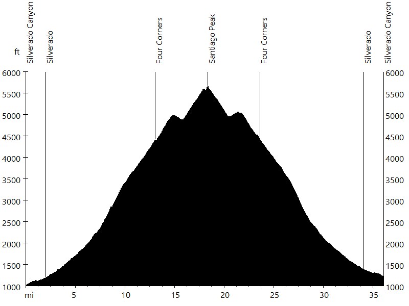
Santiago Peak via Silverado Canyon: 36 miles with 5,000 feet of climbing
Sierra Peak via Black Star, Coal Canyon, and Skyline Drive: 37 miles with 5,600 feet of climbing
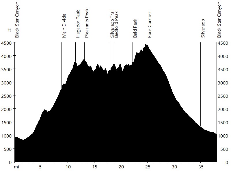
Hagador Peak, Pleasants Peak, Bedford Peak, and Bald Peak: 37 miles with 6,300 feet of climbing
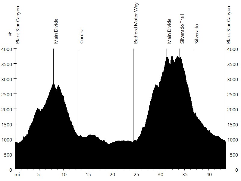
Black Star, Skyline Drive, Bedford Motor Way, and Silverado Trail: 41 miles with 6,000 feet of climbing
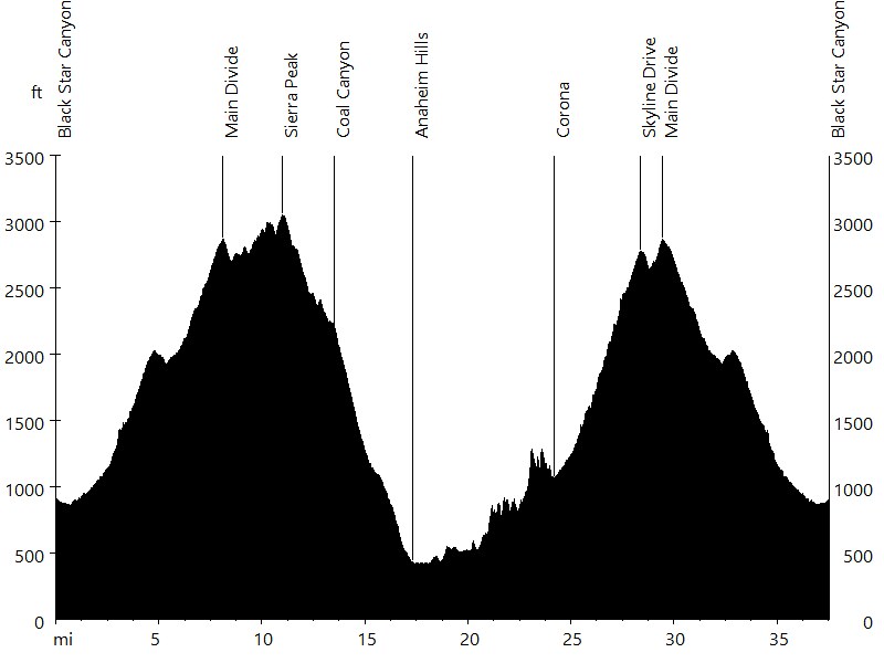
Sierra Peak via Coal Canyon and Black Star Canyon: 43 miles with 5,300 feet of climbing
Orange County is blessed with a tremendous amount of quality mountain biking, including the Santa Ana Mountains and Orange County Parks. The Santa Ana Mountains are a short mountain range along the coast of Southern California. From north to south peaks which can be accessed by trail include: Sierra Peak (3,045 feet), Hagador Peak (3,880 ft), Pleasants Peak (4,007 ft), Bedford Peak (3,800 ft), Bald Peak (3,947 ft), Modjeska Peak (5,496 ft), Santiago Peak (5,689 ft), Trabuco Peak (4,613 ft), Horsethief Peak (4,313 ft), Los Pinos Peak (4,455 ft), Old Sugarloaf Peak (3,327 ft), Sugarloaf Peak (3,228 ft), San Mateo Peak (3,593 ft), Elsinore Peak (3,575 ft), and Sitton Peak (3,225 ft). Modjeska Peak and Santiago Peak, the two highest summits in the range, form Saddleback Ridge.
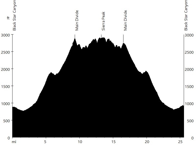
Route Profile • Sierra Peak via Black Star Canyon
Black Star Canyon Road is a fire road that starts in Black Star Canyon (off Silverado Canyon off Santiago Canyon) and leads up to the Main Divide. From the Main Divide the route follows Leonard Road to Sierra Peak.
Route Profile • Ortega Highway - Santiago Peak - Ortega Highway
?????

Route Profile • Harding Truck Trail and Silverado Canyon
Harding Truck Trail is a fire road that starts in Modjeska Canyon (off Santiago Canyon) and leads up to Four Corners. Maple Springs Truck Trail and Silverado Canyon Road lead down Silverado Canyon and back to Santiago Canyon.

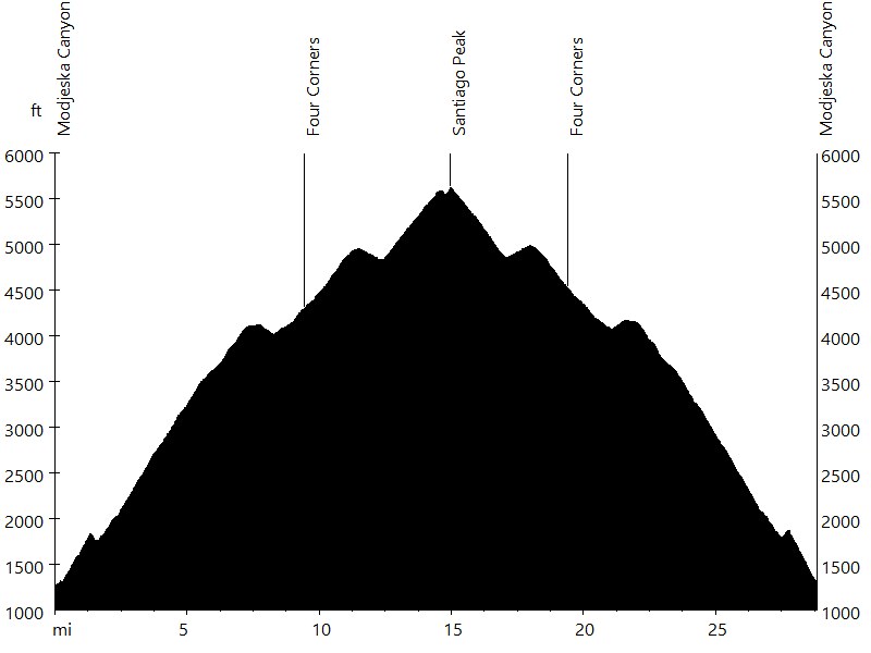
Route Profile • Santiago Peak and Modjeska Peak via Silverado Canyon
Silverado Canyon Road is a paved road that starts in Silverado Canyon (off Santiago Canyon) and leads up to Maple Springs Truck Trail, which leads up to Four Corners. From Four Corners the route follows Main Divide Road to Santiago Peak. From Santiago Peak the route leads back down, with an out-and-back section to Modjeska Peak.
Route Profile • Santiago Peak via Harding Truck Trail
Harding Truck Trail is a fire road that starts in Modjeska Canyon and leads up to Four Corners. From Four Corners the route follows Main Divide Road to Santiago Peak.
Route Profile • Black Star Canyon and Skyline Drive
Black Star Canyon Road is a fire road that starts in Black Star Canyon and leads up to the Main Divide. From the Main Divide the route follows Skyline Drive down to Corona.

Route Profile • Black Star, Skyline Drive, Eagle Road, and Silverado Trail
Black Star Canyon Road is a fire road that starts in Black Star Canyon and leads up to the Main Divide. From the Main Divide the route follows Skyline Drive down to Corona. Eagle Road is a fire road that leads back up to the Main Divide. The Main Divide then leads south to Silverado Trail. Silverado Trail is a rocky single track that leads down to Silverado Canyon Road, which leads down Silverado Canyon and back to Black Star Canyon.
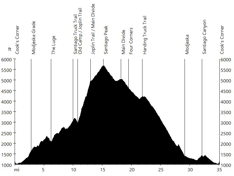
Route Profile • Santiago Peak via Joplin Trail
Santiago Canyon Road and Modjeska Grade Road lead up to Santiago Truck Trail. Santiago Truck Trail continues to lead up to Joplin Trail, passing the Luge and Old Camp. Joplin Trail is steep and rugged, unrideable for the most part (going uphill). Joplin Trail connects to Main Divide Road, which leads up to Santiago Peak. The descend follows Main Divide Road to Four Corners and Harding Truck Trail to Modjeska. Santiago Canyon Road leads back to Cook's Corner.
Route Profile • Santiago Peak via Silverado Canyon
Silverado Canyon Road is a paved road that starts in Silverado Canyon (off Santiago Canyon) and leads up to Maple Springs Truck Trail, which leads up to Four Corners. From Four Corners the route follows Main Divide Road to Santiago Peak.
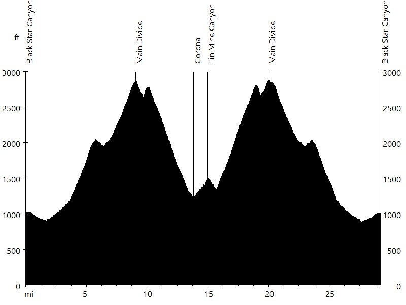
Route Profile • Sierra Peak via Black Star, Coal Canyon, and Skyline Drive
Black Star Canyon Road is a fire road that starts in Black Star Canyon and leads up to the Main Divide. From here Leonard Road leads over Sierra Peak to the top of Coal Canyon, which leads down to Anaheim Hills. The route then follows Santa Ana River Trail, Green River Road, and Foothill Parkway to Corona. Finally Skyline Drive leads back up to the Main Divide.
Route Profile • Hagador, Pleasants, Bedford, and Bald Peaks
Black Star Canyon Road is a fire road that starts in Black Star Canyon and leads up to the Main Divide. Main Divide Road leads south to Four Corners, passing the Doppler Radar, Hagador Peak (antennas), Pleasants Peak (antennas), Silverado Trail, Bedford Peak, and Bald Peak. Maple Springs Truck Trail and Silverado Canyon Road lead down Silverado Canyon and back to Black Star Canyon. For a shorter loop, Silverado Trail can be descended (25 miles with 4,400 feet of climbing).
Route Profile • Black Star, Skyline Drive, Bedford, and Silverado Trail
Black Star Canyon Road is a fire road that starts in Black Star Canyon and leads up to the Main Divide. From the Main Divide the route follows Skyline Drive down to Corona. Temescal Canyon Road then leads south to Bedford Motor Way. Bedford Motor Way is a steep fire road that leads back up to the Main Divide. The Main Divide then leads north to Silverado Trail. Silverado Trail is a rocky single track that leads down to Silverado Canyon Road, which leads down Silverado Canyon and back to Black Star Canyon.
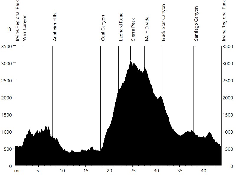
Route Profile • Sierra Peak via Coal Canyon and Black Star Canyon
This loop starts in Irvine Regional Park and follows trails to Anaheim Hills. Weir Canyon Road, Santa Ana Canyon Road, and Gypsum Canyon Road lead to Santa Ana River Trail. Coal Canyon Road leads up to Leonard Road, which leads over Sierra Peak to the top of Black Star Canyon. Black Star Canyon Road leads down to Silverado Canyon, and Santiago Canyon Road leads back to the start.
Santa Ana Mountains • Interactive Map
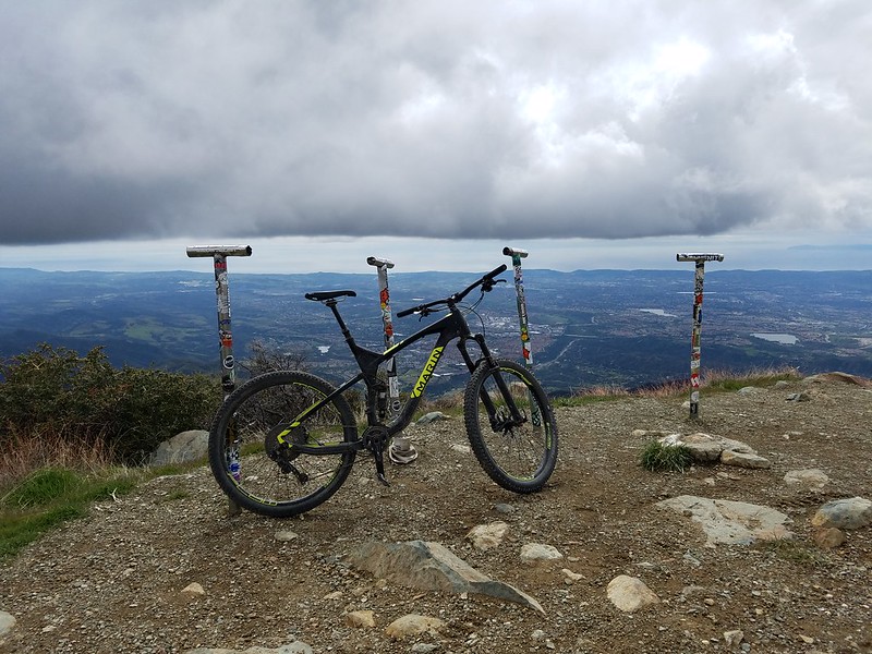
Santa Ana Mountains • Pictures

Silverado Trail

Santiago Peak

Santiago Peak in Winter
Santiago Peak

View from Modjeska Peak
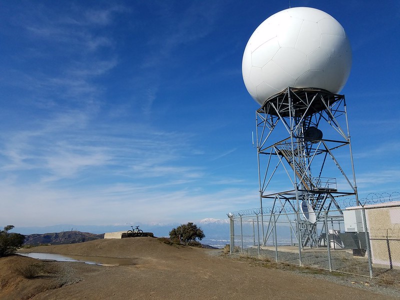
Doppler Radar

View from Doppler Radar

Old Camp
By: Bernd Straehle
See Also: Mountain Biking